Driving Alaska’s Taylor Highway: Road Conditions, Border Crossing & Best Stops

Remote. Rugged. Wildly scenic. Driving the Taylor Highway is not your typical Alaska road trip. This 160-mile route cuts through Interior Alaska’s gold rush country, climbs high above the treeline, and leads to the northernmost international border crossing in North America. It is not a drive for luxury seekers. It is a drive for travelers who want isolation, history, and vast wilderness. We drove the Taylor Highway in late summer on our way toward Dawson City and the Yukon. In this guide, we share exactly what to expect — road conditions, border crossing details, safety tips, best stops, and whether this route is right for your Alaska adventure.
This article may contain affiliate / compensated links. For full information, please see our disclaimer here.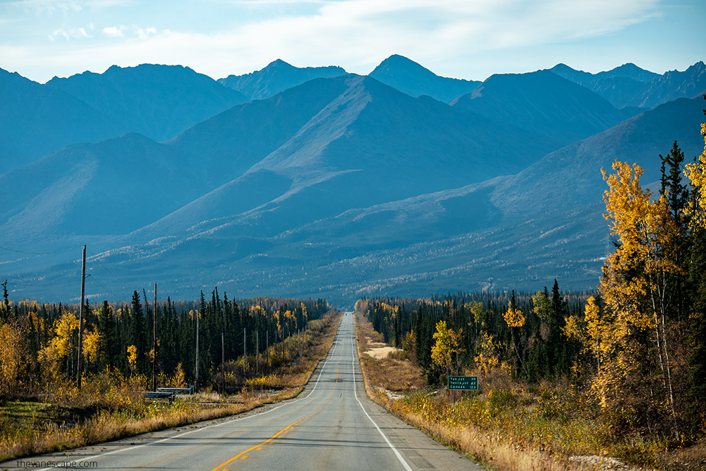
Our Experience Driving the Taylor Highway
We drove the Taylor Highway in September while exploring Interior Alaska by RV. Our goal was to reach Dawson City in Yukon and later continue toward the Dempster Highway.
By the time we turned off the Alaska Highway near Tok, we already had experience driving remote Alaska roads. Still, the Taylor Highway felt different. Traffic was almost nonexistent. Services were limited. The landscape quickly shifted from forest to open ridgelines with wide, sweeping views.
We chose to drive toward the border from Jack Wade Junction rather than continue north to Eagle. The gravel section beyond Chicken is narrow and steep in places, and we preferred to focus on the international crossing and the Top of the World Highway.
What stood out most was the isolation. For long stretches, we saw no other vehicles. No cell signal. No towns. Just rolling hills, mining remnants, and endless sky.
It is not the most famous scenic drive in Alaska. But it is one of the most authentic.
Where Is the Taylor Highway?
The Taylor Highway, officially Alaska Route 5, runs through Interior Alaska near the Canadian border. It stretches approximately 160 miles (about 258 km) from Tetlin Junction to the historic town of Eagle.
The highway begins at Tetlin Junction, located about 11 miles east of Tok on the Alaska Highway. From there, it heads north through remote gold rush country before reaching Jack Wade Junction and eventually Eagle.
At milepost 95.5, the road splits at Jack Wade Junction:
- The Boundary Spur Road turns east toward the Poker Creek–Little Gold Creek border crossing and connects with the Top of the World Highway to Dawson City, Yukon.
- The main Taylor Highway continues north to Eagle.
This location makes the Taylor Highway an important link between Alaska and Canada. In fact, the Poker Creek–Little Gold Creek Port of Entry is the northernmost international border crossing in North America.
Because of its remote setting, the Taylor Highway is often driven as part of a larger Interior Alaska road trip. Many travelers combine it with time in Tok, Chicken, Dawson City, or even extend their journey north toward the Dempster Highway.
If you are planning a broader Interior Alaska itinerary, this drive pairs well with a stay in Fairbanks before heading southeast toward Tok and the Canadian border.
Taylor Highway vs. Top of the World Highway: What’s the Difference?
Many travelers assume the Taylor Highway and the Top of the World Highway are the same road. They are connected — but they are not the same.
The Taylor Highway (Alaska Route 5) runs from Tetlin Junction near Tok to Eagle. It is entirely within Alaska.
At milepost 95.5, you reach Jack Wade Junction. Here, the Boundary Spur Road branches east and leads to the Poker Creek–Little Gold Creek border crossing. After crossing into Canada, the road becomes the Top of the World Highway.
On the Canadian side, this highway is officially Yukon Highway 9. It continues roughly 79 miles (127 km) to Dawson City.
So the structure looks like this:
- Tetlin Junction → Jack Wade Junction = Taylor Highway
- Jack Wade Junction → Border Crossing = Boundary Spur Road
- Border → Dawson City = Top of the World Highway (Yukon Highway 9)
They connect seamlessly, and many travelers drive them together in one journey. But technically, they are separate highways in two different countries.
Understanding this helps when checking road conditions, border hours, and official travel updates.
Best Time to Drive the Taylor Highway
The Taylor Highway is primarily a summer route.
Most travelers drive it between late May and September, when snow has cleared and road maintenance is active. Outside of this window, heavy snowfall and harsh winter conditions make the highway impassable for regular vehicles. In winter, the route is accessible only by snowmachine.
If you plan to cross into Canada, timing becomes even more important. The Poker Creek–Little Gold Creek border crossing is seasonal. It typically operates from early June through mid-September, with daily hours limited to daytime only. Always confirm current opening dates and hours before departure, as they can vary slightly from year to year.
Even in summer, weather can change quickly. The border crossing sits at an elevation of over 4,500 feet. Temperatures can drop suddenly, and fog or rain may reduce visibility.
Before driving the Taylor Highway, check:
- Alaska 511 for road conditions
- Border crossing hours
- Weather forecasts for Tok, Chicken, and Dawson City
Planning ahead makes a major difference on a remote road like this.
Navigating the USA–Canada Border Crossing at Poker Creek–Little Gold Creek
The Poker Creek–Little Gold Creek Port of Entry connects Alaska’s Taylor Highway with the Top of the World Highway in Yukon. It is the northernmost international border crossing in North America.
This crossing is seasonal and operates only during the summer months.
Typically, it is open from early June through mid-September. Standard operating hours are 8:00 AM to 6:00 PM Alaska Time. Keep in mind there is a one-hour time difference when entering Canada.
Because of its high elevation — over 4,500 feet — weather can be unpredictable even in summer. Cold temperatures, fog, and sudden storms are possible. Border officials advise travelers to plan for weather-related delays.
Important tips before crossing:
- Bring a valid passport.
- Ensure you meet entry requirements for Canada (visa or eTA if required).
- Do not arrive close to closing time — there are no nearby services.
- Fuel up before leaving Tok or Dawson City.
- Check official border websites for updated hours.
There are no services at the crossing itself. No fuel. No food. No cell service. Plan carefully.

Road Conditions on the Taylor Highway: Paved or Gravel?
Road conditions on the Taylor Highway change along the route.
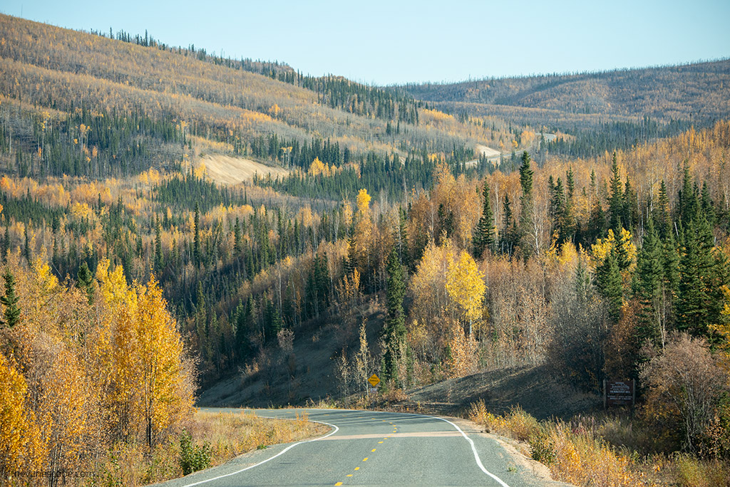
The first section, from Tetlin Junction to approximately Mile 64.3 (near the Mosquito Fork Fortymile River Bridge, about 2 miles south of Chicken), is paved. However, do not expect smooth highway driving. Frost heaves are common, and some sections can feel uneven or rough.
After Mile 64.3, the highway transitions to gravel.
From this point north, road conditions depend heavily on recent grading and weather. Some stretches are well-maintained and fairly smooth. Others can be washboarded, dusty, muddy after rain, or rutted.
The stretch between Chicken and Eagle is the most challenging. It is narrow, steep in places, and includes sharp curves. Shoulders can be soft and unstable. Large RVs and campers are generally not recommended on this section. However, driving to Eagle is not mandatory if your goal is Dawson City and the Top of the World Highway.
Important things to know:
- 4WD is not required in summer under normal conditions.
- Drive slowly and expect sudden rough patches.
- Watch for loose gravel, especially on curves.
- Road maintenance may be limited late in the season.
Traffic is extremely light. You may drive long distances without seeing another vehicle.
Because of the remote nature of the road, always carry:
- A full tank of fuel
- A spare tire in good condition
- Basic emergency supplies
This is not a dangerous highway if driven cautiously. But it is remote and unforgiving if you are unprepared.

Is Driving the Taylor Highway Dangerous?
The short answer: no — not if you are prepared and drive carefully.
The Taylor Highway is remote, but it is not inherently dangerous in summer conditions. You do not need a 4WD vehicle during normal summer weather. Most passenger cars can handle the road if driven slowly and cautiously.
The key risks are not extreme terrain. The real challenge is isolation.
You may drive long stretches without seeing another vehicle. There is little to no cell phone service. Services are minimal. If you experience a breakdown, help may not arrive quickly.
Compared to other northern routes:
- The Dalton Highway is more demanding and rougher.
- The Dempster Highway is longer and more remote.
The Taylor Highway feels manageable in comparison — especially the paved section before Chicken.
To stay safe:
- Drive slowly on gravel.
- Avoid sudden braking on loose surfaces.
- Watch for wildlife, especially caribou and moose.
- Do not rush to make the border before closing time.
This is a road that rewards patience.
If you respect the conditions and prepare properly, the Taylor Highway is a memorable and very doable Alaska adventure.
Cell Phone Coverage and Navigation
Do not expect reliable cell phone service on the Taylor Highway.
During our drive, reception was virtually nonexistent. That included large portions of the highway and continued even after crossing into Yukon. Service did not return consistently until we reached Dawson City.
Because of this, plan as if you will be offline the entire time.
Before you leave Tok or Dawson City:
- Download offline maps (Google Maps or similar).
- Save key locations in advance.
- Check road conditions and border hours.
- Inform someone of your route and expected arrival time.
A printed road guide is extremely helpful on this route. The Milepost remains one of the most detailed resources for Alaska and northern Canada road trips. It includes mile-by-mile descriptions, service points, campgrounds, and historical notes. We relied on it not only here but also while driving the Dalton Highway and other remote Alaska roads.
Navigation is straightforward — there are few intersections — but preparation matters. Once you are on the Taylor Highway, you are committed to the drive.
A Brief History of the Taylor Highway
The Taylor Highway follows a path shaped by Alaska’s early gold rush.
Gold was discovered in the Fortymile region between 1881 and 1886. Larger strikes in 1887 and 1888 triggered the first major gold rush in Interior Alaska. Mining settlements such as Chicken, Jack Wade, and Franklin appeared almost overnight.
Early miners traveled by foot, horseback, and river routes between Eagle and the Fortymile district. Over time, these rough trails evolved into wagon roads.
In 1953, the modern highway was constructed to provide reliable access to Eagle, Chicken, and the Fortymile Mining District. It also created a transportation link to the Fortymile River system, now designated a National Wild and Scenic River.
Originally known as the Fortymile Road, the highway was later renamed in honor of Ike Taylor, who served as chief engineer of the Alaska Road Commission from 1932 to 1948.
Today, driving the Taylor Highway feels like traveling through layers of history. Abandoned mining remnants, historic sites, and small frontier communities still reflect that gold rush legacy.
Wildlife remains part of the landscape as well. The Fortymile caribou herd often moves through this region, adding another connection between past and present.
Best Stops on the Taylor Highway
The Taylor Highway is not lined with attractions. That is part of its appeal. Stops are spaced far apart, and each one feels remote and authentic.
Here are the most meaningful places to explore along the route.
Tetlin Junction
Your journey begins at Tetlin Junction, about 11 miles east of Tok on the Alaska Highway.
As you turn north onto the Taylor Highway, views begin to open toward the Alaska Range and the Mentasta Mountains. On clear days, the landscape feels wide and untouched. This is where traffic drops off and the wilderness drive truly begins.
Fortymile Goldfields
The highway passes through the historic Fortymile Mining District, one of Alaska’s earliest gold-producing regions.
Gold discoveries here in the late 1880s sparked Interior Alaska’s first major gold rush — even before the Klondike rush of 1897. Mining activity shaped the development of settlements like Chicken, Jack Wade, and Franklin.
The Fortymile River, now designated a National Wild and Scenic River, runs through this region. It stretches roughly 400 miles and remains popular for rafting and remote river trips.
Keep your eyes open for wildlife. The Fortymile caribou herd frequently moves through this area, along with moose and other wildlife.
Chicken, Alaska
Chicken is one of Alaska’s most unusual and memorable stops.
The town was named “Chicken” because early settlers wanted to name it after the ptarmigan, Alaska’s state bird. They simply could not agree on how to spell it.
Today, Chicken remains one of Alaska’s few surviving gold rush communities. The population is extremely small — just a handful of year-round residents.
You can:
- Visit the historic gold dredge
- Try recreational gold panning
- Explore small museums and gift shops
- Eat at seasonal cafés
Chicken also serves as an important fuel and rest stop before continuing toward the border or Eagle.
Jack Wade Junction
At milepost 95.5, you reach Jack Wade Junction.
Here, the Boundary Spur Road branches east toward the Poker Creek–Little Gold Creek border crossing and the Top of the World Highway. On clear days, the surrounding ridgelines stretch toward Canada’s Ogilvie Mountains.
This junction is a key decision point:
- Continue north to Eagle
- Turn east toward Dawson City
Many travelers choose the Dawson City route because it connects directly to the Top of the World Highway and opens the door to further Yukon adventures.

Eagle, Alaska
If you continue north instead of turning toward the border, the Taylor Highway leads to Eagle.
Founded in 1897 during the Klondike Gold Rush, Eagle once served as a center of law enforcement and military presence in Interior Alaska. The U.S. Army established Fort Egbert here to maintain order during the gold rush era.
Today, Eagle remains a small community with just over 100 residents.
You can explore:
- Fort Egbert National Historic Landmark
- Historic buildings preserved by the Eagle Historical Society
- Scenic views along the Yukon River
However, driving to Eagle is not mandatory if your goal is Dawson City or the Top of the World Highway.
Many travelers turn east at Jack Wade Junction and skip the final stretch to Eagle. The section between Chicken and Eagle is fully gravel, narrow in places, and includes steep grades and sharp curves. Larger RVs and trailers are generally discouraged on this segment.
If you are short on time or prefer easier road conditions, it is completely reasonable to skip Eagle and focus on the border crossing instead.


Where to Stay Along the Taylor Highway
Accommodation options along the Taylor Highway are limited and seasonal. Plan ahead and confirm operating dates before you go.
Overnight camping is not permitted at most BLM roadside pullouts and waysides along the highway. You must use designated campgrounds.
Here are the main options:
West Fork Campground (Milepost 49)
Located at Milepost 49, West Fork Campground offers river access and space for both cars and RVs.
From the scenic overlook above the campground, you can often spot trumpeter swans and moose in the wetlands below. This area marks the southernmost public access point to the 400-mile Fortymile National Wild and Scenic River system.
This is a quiet and remote stop with very limited services.
Chicken Gold Camp & Outpost (Milepost 65.3)
In Chicken, you’ll find one of the most established overnight options along the highway.
Chicken Gold Camp & Outpost offers:
- RV sites
- Tent camping
- Cabin rentals
- A seasonal restaurant
- Gift shop
- Historic gold dredge and small museum
- Gold panning and mining tours
Because services along the highway are sparse, many travelers choose to overnight in Chicken before continuing toward the border or Eagle.
Walker Fork Campground (Milepost 82)
Operated by the Bureau of Land Management (BLM), Walker Fork Campground offers 18 campsites.
This site has historical significance. In the 1930s and 1940s, the Lassen Airstrip was located here. Supplies once arrived by air and by winter sled routes to support mining operations in the region.
Facilities are basic, and availability may be seasonal.
Eagle Campground
Near the town of Eagle, this campground offers 18 campsites within walking distance of the village and historic Fort Egbert.
It is one of the few organized options if you decide to continue north to Eagle.
Because distances are long and services are minimal, always:
- Confirm campground status before departure
- Carry sufficient water
- Fuel up before leaving Tok or Dawson City
This is not a drive where you want to search for last-minute accommodation.
Essential Safety Tips for Driving the Taylor Highway
The Taylor Highway rewards preparation. It is remote, lightly traveled, and services are limited. A little planning goes a long way.
Here are the most important things to keep in mind:
Fuel and Supplies
Fuel is not available along most of the highway. Fill your tank in Tok before starting the drive, or in Dawson City if coming from Canada.
Carry:
- Extra water
- Snacks or meals
- Basic emergency supplies
- A spare tire in good condition
Do not assume stores in Chicken or Eagle will be open. Hours can vary, especially late in the season.
Check Road and Border Conditions
Before you leave:
- Check Alaska 511 for current road conditions.
- Confirm Poker Creek–Little Gold Creek border hours.
- Review weather forecasts, especially near the high-elevation crossing.
Arriving after the border closes can create major logistical problems.
Drive During Daylight
Plan to drive during daylight hours. Visibility is better, wildlife is easier to spot, and navigation is simpler.
Even in summer, weather can change quickly. Fog and rain can reduce visibility on higher ridgelines.
Stay on the Main Route
The Taylor Highway passes through remote areas that are popular for seasonal hunting. Do not venture off established roads or explore side trails unless you are fully informed about the area.
Stay on the main route and respect posted signs. This reduces risk and avoids interfering with hunting activity.
Use Designated Campgrounds Only
Overnight camping is not allowed at most roadside pullouts and BLM waysides along the highway.
Plan your accommodations in advance and use designated campgrounds such as West Fork, Walker Fork, Chicken Gold Camp, or Eagle Campground. Do not assume you can simply stop anywhere for the night.
Respect the Remoteness
There is little to no cell service. Traffic is sparse. Help may not arrive quickly in case of a breakdown. Let someone know your route. Download offline maps. Take your time. The Taylor Highway is not difficult — but it demands respect and preparation.
Final Thoughts
The Taylor Highway is not Alaska’s most famous scenic drive. It does not have cruise ship crowds or busy visitor centers.
You drive through gold rush country where settlements rose almost overnight. You cross wide ridgelines with views stretching toward Canada. You experience one of the most remote international border crossings in North America.
It requires preparation. It rewards patience.
If you are planning a road trip through Interior Alaska and want something less traveled, the Taylor Highway is worth considering.
It may not be for everyone — but for the right traveler, it is unforgettable.
Do You Like It? Pin It For Later!