Alaska Weather by Region: What to Expect

Alaska weather is not one-size-fits-all. Conditions change dramatically depending on where you go, even within the same month. Coastal towns, interior cities, and Arctic regions can experience completely different temperatures, precipitation, and daylight on the same day. That’s why general advice about “Alaska weather” often falls short. This guide explains what to realistically expect by region, not by month. It focuses on typical patterns that matter for trip planning, including temperature ranges, rain versus snow, wind exposure, and how weather affects travel on the ground. Instead of forecasts or averages taken out of context, this article helps you understand how Alaska’s major regions behave so you can plan routes, timing, and expectations with confidence.
This article may contain affiliate / compensated links. For full information, please see our disclaimer here.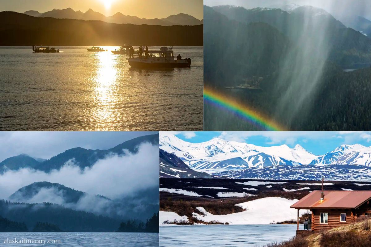
Our Experiences With Alaska Weather Across Regions
Over the years, we’ve experienced Alaska weather in very different regions and travel seasons. Chris and I have driven long stretches of Alaska highways, explored coastal towns, spent time in the Interior, and returned during summer, shoulder season, and winter.
What stood out quickly is how much location matters. A rainy day in Southeast Alaska can feel mild and damp, while the same day in the Interior may be dry and warm. Coastal wind can change how cold it feels, even when temperatures look similar on paper. In winter, snow and ice shape travel in some regions, while others remain more manageable due to milder coastal conditions.
These firsthand experiences shaped how we plan Alaska trips today. Instead of relying on statewide averages, we look at regional weather patterns first. That approach leads to better expectations, smarter routes, and fewer surprises on the road.
Agnes’ Advice: This guide focuses on how weather differs across Alaska. If you’re still planning your Alaska trip, take a look at our breakdown of Alaska’s five regions, what makes each one unique, and when is the best time to visit Alaska based on different travel goals.


Why Alaska Weather Varies So Much
Alaska’s size and geography create distinct climate zones, not a single statewide pattern. Three main factors drive these differences.
Ocean Influence vs. Interior Climate
Coastal Alaska is shaped by the Pacific Ocean. The ocean moderates temperatures, keeping winters milder and summers cooler. It also adds moisture, which means more frequent precipitation and cloud cover, especially in Southeast and along parts of the Gulf of Alaska.
Interior Alaska sits farther from the ocean. Without that moderating influence, temperatures swing more dramatically. Summers can be noticeably warmer, while winters are much colder. Precipitation is generally lower, and conditions are often drier.
Mountain Barriers
Alaska’s mountain ranges act as weather walls. The Alaska Range, Chugach Mountains, and Coast Mountains block moist air from moving inland. As a result, coastal regions receive far more rain and snow, while Interior areas remain comparatively dry.
This is why you can cross a mountain pass and experience a completely different climate within a short drive.
Latitude and Daylight
Latitude affects both temperature and daylight. Northern regions receive less solar energy overall and experience more extreme daylight changes. Long summer days can increase warming, while winter darkness intensifies cold and limits daily travel windows.
Together, ocean influence, mountains, and latitude explain why Alaska weather must be understood by region, not by calendar month.
Alaska Weather by Region: Key Differences at a Glance
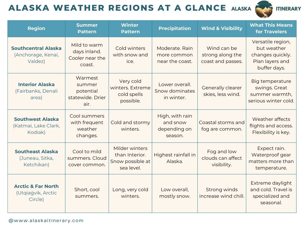
This overview compares 5 Alaska’s major regions based on typical weather patterns that matter for trip planning. Alaska’s regions behave very differently when it comes to weather, even within the same month.
The table below compares broad seasonal patterns—summer, winter, precipitation, wind, and visibility—across each major region. It’s a quick way to see how conditions shift geographically before looking at detailed numbers.
Alaska Temperatures Comparison by Region
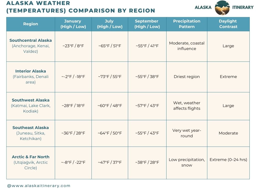
This temperatures comparison uses January, July, and September to highlight how Alaska’s regions differ in true winter, peak summer, and shoulder season conditions. This will help you decide where to go in Alaska based on the month you plan to visit.
Now, let’s take a closer look at each region, one by one, to see how these weather patterns and seasonal differences affect real travel conditions.
We use January, July, and September as representative months—January shows true winter conditions, July highlights peak summer patterns, and September captures the shoulder-season transition—to clearly illustrate how weather differs across Alaska’s regions.
All values below are regional averages based on NOAA / NWS normals, using representative locations:
- Southeast: Juneau
- Southcentral: Anchorage
- Interior: Fairbanks
- Southwest: King Salmon / Kodiak area
- Far North / Arctic: Utqiaġvik (Barrow)
Southcentral Alaska Weather
Southcentral Alaska includes Anchorage, the Kenai Peninsula (Seward, Homer, Cooper Landing), the Matanuska–Susitna Valley (Palmer, Wasilla), and Valdez. This is one of the most visited regions in Alaska and the main hub for road trips.
- Southcentral Alaska (Anchorage / Kenai Peninsula / Valdez)
| Month | Avg High | Avg Low | Daylight | Precipitation |
|---|---|---|---|---|
| January | ~23°F | ~8°F | ~5.5 hrs | ~0.8 in |
| July | ~65°F | ~51°F | ~19 hrs | ~2.0 in |
| September | ~55°F | ~41°F | ~12.5 hrs | ~3.0 in |
Key takeaway: Big daylight swings, moderate precipitation, strong seasonal contrast.
Temperature Patterns
Weather in Southcentral Alaska varies based on distance from the ocean.
- Summer: typically 55–70°F, with warmer days inland (Palmer, Wasilla) and cooler conditions near the coast (Seward, Homer, Valdez)
- Winter: generally 5–30°F, with colder temperatures inland and milder conditions closer to the coast
Warm summer days are common, especially on clear days. Coastal locations tend to stay cooler due to marine influence.
Precipitation and Snow
Precipitation is moderate across the region, but unevenly distributed.
Coastal areas like Seward, Homer, and Valdez receive more rain, especially in late summer and fall. Inland locations such as Anchorage, Palmer, and Wasilla are typically drier.
In winter, precipitation falls mostly as snow. Snow cover is common and can persist for months, especially inland and at higher elevations.
Wind and Local Effects
Wind plays a major role in Southcentral Alaska weather.
Strong winds are common along Turnagain Arm, in mountain passes, and near the coast. Wind chill can make temperatures feel colder than expected, particularly in winter and shoulder seasons.
What This Means for Travelers
Southcentral Alaska offers some of the most flexible travel conditions in the state, but weather varies significantly within short distances. Layered clothing, weather checks by location, and realistic driving plans are essential.
Understanding these local differences helps with planning road trips, coastal stops, and inland travel days without surprises.

Interior Alaska Weather
Interior Alaska includes Fairbanks, the Denali National Park area, and communities along the Alaska Range. This region has a continental climate, which means the largest temperature swings in the state.
- Interior Alaska (Fairbanks / Denali Area)
| Month | Avg High | Avg Low | Daylight | Precipitation |
|---|---|---|---|---|
| January | ~-2°F | ~-18°F | ~4 hrs | ~0.4 in |
| July | ~73°F | ~55°F | ~22 hrs | ~2.3 in |
| September | ~55°F | ~38°F | ~12.5 hrs | ~1.5 in |
Key takeaway: Coldest winters, warmest summers, driest region overall.
Temperature Patterns
Interior Alaska experiences warm summers and very cold winters.
- Summer: typically 65–80°F, with warmer days possible during clear weather
- Winter: commonly –20 to 10°F, with colder periods during extended cold snaps
Summer warmth often surprises first-time visitors. Clear days can feel hot, especially around Fairbanks. In winter, cold is persistent and can be severe, particularly during long stretches of high pressure.
Precipitation and Snow
Interior Alaska is drier than coastal regions.
Rainfall is lower overall, especially in summer. Snow dominates winter precipitation, and snow cover usually lasts from late fall through early spring. Because snowfall is lighter than in coastal areas, roads may remain passable even during winter, but ice and extreme cold create their own challenges.
Wind, Visibility, and Seasonal Factors
Wind is generally less intense than along the coast, which can make cold temperatures feel more manageable than expected. Clear skies are more common, especially in winter, improving visibility for landscapes and Northern Lights viewing.
In summer, dry conditions can increase the risk of wildfire smoke, which may temporarily affect air quality and visibility during active fire seasons.
What This Means for Travelers
Interior Alaska offers the warmest summer conditions and the coldest winter travel in the state. Seasonal contrast is extreme. Summer favors long daylight hours and comfortable hiking conditions, while winter travel requires preparation for severe cold and limited daylight.
Travelers should plan with temperature swings in mind and expect very different conditions depending on season and weather patterns.

Southwest Alaska Weather
Southwest Alaska includes Katmai National Park, Lake Clark National Park, and the Bristol Bay region. Weather here is strongly influenced by the Bering Sea and the Gulf of Alaska, which makes conditions more variable and access more weather-dependent than in many other parts of the state.
- Southwest Alaska (Katmai / Lake Clark / Bristol Bay)
| Month | Avg High | Avg Low | Daylight | Precipitation |
|---|---|---|---|---|
| January | ~28°F | ~18°F | ~6 hrs | ~2.5 in |
| July | ~60°F | ~48°F | ~17 hrs | ~3.0 in |
| September | ~57°F | ~43°F | ~12.5 hrs | ~4.0 in |
Key takeaway: Cool summers, frequent rain, weather strongly affects access.
Temperature Patterns
Temperatures in Southwest Alaska stay cooler year-round compared to the Interior.
- Summer: typically around 50–65°F
- Winter: generally around 0–25°F
Warm days are possible in summer, but prolonged heat is uncommon. Cold spells occur in winter, though temperatures are usually less extreme than in Interior Alaska.
Precipitation and Cloud Cover
Precipitation levels are high, especially along the coast.
Rain is common from late spring through fall. In winter, precipitation falls as snow, often mixed with rain near sea level during milder periods. Cloud cover is frequent, and weather systems can move in quickly.
Because of this, conditions can shift noticeably within a single day.
Wind and Coastal Effects
Wind is a major factor in Southwest Alaska.
Coastal storms, strong winds, and low ceilings are common, particularly outside peak summer. Fog and wind can affect small-plane access, which is the primary way travelers reach Katmai and Lake Clark.
Marine conditions also influence visibility and sea state, which matters for boat travel and coastal activities.
What This Means for Travelers
In Southwest Alaska, weather directly affects access. Flights may be delayed, rescheduled, or canceled due to wind, fog, or low clouds. Flexibility is essential, especially for trips involving bush planes or remote lodges.
Travelers should build extra time into itineraries and expect plans to adjust around conditions. This region rewards patience and realistic expectations more than rigid schedules.
Arctic & Far North Alaska Weather
The Arctic and Far North include Utqiaġvik (Barrow) and areas north of the Arctic Circle to Prudhoe Bay. This is Alaska’s most extreme climate zone, shaped by high latitude, sea ice, and persistent wind.
- Arctic & Far North (Utqiaġvik / Gates of the Arctic)
| Month | Avg High | Avg Low | Daylight | Precipitation |
|---|---|---|---|---|
| January | ~-8°F | ~-22°F | 0 hrs | ~0.3 in |
| July | ~47°F | ~37°F | 24 hrs | ~1.2 in |
| September | ~38°F | ~28°F | ~12 hrs | ~1.0 in |
Key takeaway: Extreme daylight variation, cool summers, true Arctic conditions.
Temperature Patterns
Temperatures remain cool to cold year-round, with a short, subdued summer.
- Summer: typically around 40–55°F
- Winter: often –30 to 0°F, with colder wind chill during storms
Even in summer, temperatures can feel cool, especially near the coast. In winter, cold is constant rather than episodic.
Precipitation and Snow
Total precipitation is low, but snow dominates for much of the year.
Snowfall is usually light and dry compared to coastal Alaska, but snow cover persists for long periods due to cold temperatures. Rain is rare and limited to the brief summer season.
Wind, Sea Ice, and Visibility
Wind is one of the most defining factors in the Arctic.
Strong winds increase wind chill and can significantly lower perceived temperatures. Sea ice and coastal conditions influence local weather, especially near Utqiaġvik. Blowing snow can reduce visibility, even when snowfall amounts are modest.
Daylight extremes are pronounced. Summer brings continuous daylight, while winter includes long periods of darkness, which shapes daily activity and travel timing.
What This Means for Travelers
Travel in the Arctic and Far North is highly specialized. It is not a region for casual sightseeing or spontaneous itineraries. Weather, daylight, and access require careful planning and flexibility.
Trips here are usually goal-driven and short in scope, with a strong emphasis on local logistics and safety. Understanding Arctic weather patterns is essential before committing to travel in this part of Alaska.

Southeast Alaska Weather (Inside Passage)
Southeast Alaska has a maritime climate shaped by the Pacific Ocean. This region behaves very differently from the rest of the state, and it often surprises first-time visitors. It’s mostly wisited during Alaska cruises.
| Month | Avg High | Avg Low | Daylight | Precipitation |
|---|---|---|---|---|
| January | ~36°F | ~28°F | ~7 hrs | ~5.5 in |
| July | ~64°F | ~50°F | ~17 hrs | ~4.5 in |
| September | ~55°F | ~43°F | ~12.5 hrs | ~8.0 in |
Key takeaway: Mild temperatures year-round, but consistently wet.
Temperature Patterns
Temperatures in Southeast Alaska stay moderate year-round compared to Interior Alaska.
- Summer: typically around 50–65°F
- Winter: often around 25–40°F
Extreme heat and extreme cold are rare here. The ocean moderates temperatures in every season.
Precipitation and Cloud Cover
Southeast Alaska is the wettest region in the state.
Rain is frequent throughout the year, especially from late summer through fall. Snow can fall in winter, even at sea level, but it often mixes with rain and does not always linger. Persistent cloud cover is common and can affect visibility.
This does not mean it rains nonstop, but it does mean travelers should expect wet conditions at some point during their trip.
Wind and Visibility
Coastal winds and low cloud ceilings are common, particularly in exposed areas and during storms. Fog can affect marine travel, scenic views, and flight schedules.
Visibility changes quickly. A clear morning can turn overcast within hours.
What This Means for Travelers
In Southeast Alaska, rain management matters more than temperature. Waterproof layers, flexible schedules, and realistic expectations make a big difference. Weather rarely shuts travel down completely, but it often shapes how the day unfolds.
This region rewards travelers who plan for moisture rather than cold.

What Alaska Weather By Reagion Means for Real Trip Planning
Understanding Alaska’s regional weather helps set realistic expectations and shapes how trips should be planned. Conditions do not just affect comfort. They influence access, timing, and how much you can realistically do in a day.
Weather Affects Access, Not Just Activities
Rain, snow, wind, and temperature directly affect transportation. Coastal storms and low clouds can delay flights and boats. Freeze–thaw cycles impact gravel roads and trails. Snow and ice slow driving speeds, even on major highways.
Planning realistic distances matters more than chasing perfect conditions.
Layering Matters in Every Season
Temperature swings are common across regions. A warm inland afternoon can turn cool quickly near the coast. Even in summer, mornings and evenings often feel chilly.
Layering works better than packing for a single forecast. This is true year-round, including summer.
Visibility Can Change the Experience
Cloud cover, fog, and smoke affect views and wildlife spotting more than temperature does. Coastal regions often trade clear skies for dramatic clouds. Interior regions usually have better visibility, but wildfire smoke can reduce it during active seasons.
Build flexibility into scenic days rather than locking them to one specific date.
Build Buffer Time Into the Itinerary
Weather-related delays are part of Alaska travel. Extra time helps absorb:
- delayed flights in coastal and remote regions
- road closures or slowdowns
- rescheduled tours
Trips with built-in buffer days are consistently more enjoyable and less stressful.
Region-First Planning Works Best
Instead of asking, “What will Alaska weather be like in this month?” ask, “What will the weather be like where I’m going?” Regional planning leads to better route choices, smarter timing, and fewer surprises.

Where to Check Alaska Weather and Conditions Reliably
For Alaska trip planning, official and location-specific sources matter more than generic weather apps. Conditions can change quickly, and statewide summaries are often misleading.
National Weather Service (NWS) Alaska
The National Weather Service Alaska (NWS Alaska) provides the most reliable forecasts for cities, highways, mountain passes, and coastal areas. Forecasts are issued by regional offices that understand local terrain and weather patterns.
This is the best source for:
- short-term and extended forecasts
- wind, marine, and aviation weather
- winter storm and travel advisories
Alaska Weather Information Line (AWIL)
The Alaska Weather Information Line (AWIL) is a practical tool for travelers on the move. It offers recorded updates focused on road conditions, regional weather, and travel impacts, especially useful in winter and shoulder season.
AWIL is often more helpful than an app when you need a quick reality check before driving.
National Park Service (NPS) Park Pages
For national parks, always check the NPS “Plan Your Visit”, “Alerts” and “Hours & Seasons” pages. These pages explain:
- seasonal road access
- shuttle operations
- trail conditions
- weather-related closures
Park weather can differ significantly from nearby towns.
Alaska Department of Transportation (DOT)
For road trips, the Alaska DOT provides updates on:
- highway conditions
- construction zones
- closures and delays
This is especially important in shoulder season and winter, when freeze–thaw cycles and snow affect travel.
Why Apps Alone Aren’t Enough
Weather apps often average data over wide areas. In Alaska, that can mean missing:
- mountain pass conditions
- coastal wind events
- localized snow or rain bands
Cross-checking official sources leads to better decisions and fewer surprises.
Final Thoughts
Alaska weather is best understood by region, not by month. Coastal influence, distance from the ocean, mountains, and latitude all shape conditions in ways that statewide averages cannot capture.
Knowing what to expect in the specific areas you plan to visit helps you pack better, plan smarter routes, and build realistic itineraries. Weather in Alaska rarely stops travel entirely, but it often shapes how each day unfolds.
When you plan with regional patterns in mind, Alaska becomes easier to navigate and far more predictable than its reputation suggests.
Do You Like It? Pin It for Later!